Where Is Nafplio Located In Greece?
Nafplio sits on the Argolic Gulf in the Argolid, in the north-east Peloponnese of mainland Greece, about 141 km from Athens by road. Here is exactly where, and what surrounds it.
Nafplio is a coastal town of about 14,500 residents in the Argolid, the easternmost regional unit of the Peloponnese, on the mainland of southern Greece. It faces the Argolic Gulf, the deep inlet of the Aegean that separates the Argolid peninsula from the eastern side of the Peloponnese, and its centre, Syntagma Square, sits at the foot of the rock on which Palamidi Fortress stands 216 m above the Old Town. Athens is about 141 km away by road, Mycenae about a 32-minute drive, and the theatre of Epidaurus about 41 minutes, which is precisely why the town works so well as a base for the whole region. This page answers the question of location in full: the region, the distances, the common island confusion, and what the surrounding geography actually looks like on the ground.
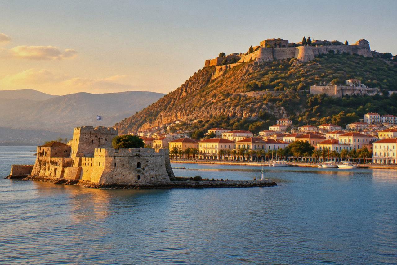
Where Is Nafplio Located In Greece?
Nafplio is located in the Argolid, in the north-east of the Peloponnese, on the mainland of southern Greece, on the north shore of the Argolic Gulf. Its centre, Syntagma Square, geocodes to 37.566021 north and 22.796822 east. It is a mainland port town, not an island, roughly 141 km by road from Athens and about 127 minutes of driving from Syntagma Square in the capital.
That single sentence settles the geography, but the detail matters for planning. The Peloponnese is the large peninsula of southern Greece, linked to the mainland across the Corinth Canal, and the Argolid is its eastern regional unit, the peninsula that ends in capes on either side of the Argolic Gulf. Nafplio sits near the head of that gulf, on its northern shore, with the harbour opening south-east toward the water. The Nafplio Travel Guide covers the town sight by sight, but location is the foundation: almost every day trip from the town, and the whole shape of a visit, follows from where it sits.
Three spatial anchors fix the town in the mind. First, the rock: Palamidi Fortress crowns the hill directly above the Old Town at 216 m, with the stairway of about 850 steps (not the legendary 999) climbing its flank. Second, the water: the harbour holds Bourtzi, the small fortified islet, and the Arvanitia Promenade runs about 1 km around the foot of Akronafplia, the old acropolis above the harbour. Third, the plain: behind the town opens the Argive plain, the agricultural flatland that runs inland to Argos, Lerna and Mycenae. For a sense of the town itself, the things to do in Nafplio page maps the sights onto this geography, and the question of how many days you need in Nafplio depends heavily on how much of the surrounding Argolid you intend to fold in.
What Region Is Nafplio In?
Nafplio is in the Argolid, also called Argolis, one of the regional units of the Peloponnese region of Greece. Its wider municipality held about 32,600 residents at the 2021 census, with the town itself at 14,532, according to ELSTAT. The town was the capital of Greece from 1827 to 1834, which is why its administrative and architectural weight so far exceeds its size.
The Argolid is one of the most historically loaded corners of Greece. Within roughly an hour's drive of Syntagma Square lie Mycenae and Tiryns, jointly inscribed by UNESCO as the Archaeological Sites of Mycenae and Tiryns in 1999, and the Sanctuary of Asklepios at Epidaurus, inscribed in 1988. Argos, one of the region's other main towns, is about 18 minutes away by car, and the beach resort of Tolo about 17. The regional unit also covers the wine country of Nemea, whose vineyards sit about 49 minutes away, and the coast road south-east to Palaia Epidavros and the fishing harbours of Ermioni and Porto Heli. If you are weighing the wider peninsula, the pages on what the Peloponnese is famous for and whether the Peloponnese is worth visiting set the region in context, and what Nafplio is famous for covers the town's own identity.
Positioning yourself in the region is easiest with a local operator for at least one outing. A cycling, sightseeing and tasting loop covers the town's setting in a single circuit, while a shared half-day excursion reaches Mycenae and Epidaurus, the two flagship sites of the Argolid, without the logistics of driving yourself.
How Far Is Nafplio From Athens?
Nafplio is about 141 km from central Athens by road, a computed drive of roughly 127 minutes from Syntagma Square to Syntagma, and about 171 km, or roughly 2 hours 19 minutes, from Athens airport. There is no passenger train to Nafplio in 2026; the practical links are the KTEL Argolida coach, reported at 15.70 euro one way for a journey of about 2 hours 10 minutes, or a hired or private car.
The drive runs on the Olympia Odos and Moreas motorways and crosses the Isthmus near the Corinth Canal, which is open to shipping, so the canal viewpoint is a natural stop on the way down. Computed drive times from Syntagma Square in Nafplio to the key nodes: Kifissos KTEL terminal in Athens 138 km in about 2 hours 02, Athens airport 171 km in about 2 hours 19, and Ancient Corinth 57.1 km in about 61 minutes. The coach fare is a reported figure from the operator's own fares page, so confirm it before travel. The details, including the airport transfer question and the train myth, are covered in full on how to get from Athens to Nafplio and the train question, and the Athens airport taxi question has its own page.
| From Nafplio, Syntagma Square | Distance | Drive time |
|---|---|---|
| Athens (Syntagma) | 141 km | about 127 min |
| Athens airport | 171 km | about 2 h 19 |
| Kifissos KTEL terminal, Athens | 138 km | about 2 h 02 |
| Argos | 14.5 km | about 18 min |
| Mycenae | 25.4 km | about 32 min |
| Epidaurus theatre | 27.7 km | about 41 min |
| Nemea town | 46.0 km | about 49 min |
| Ancient Corinth | 57.1 km | about 61 min |
| Corinth Canal | 68.9 km | about 72 min |
Is Nafplio An Island?
No, Nafplio is not an island. It is a mainland town on the shore of the Argolic Gulf, in the Peloponnese. The only island in the picture is Bourtzi, the small fortified islet in the town's own harbour, reached by boat, and even that is a sea fort rather than a residential island. Greece is a Schengen member and uses the euro, and Nafplio is reached entirely by road or coach.
The confusion usually comes from two directions. Nafplio's harbour imagery, Bourtzi floating offshore and boats in the foreground of nearly every photograph, reads as insular, and the town is often mentioned in the same breath as the Saronic islands of Hydra and Spetses. The fact is that no scheduled public ferry runs from Nafplio or Tolo to Hydra or Spetses; older guides suggesting otherwise are out of date, and the islands are reached by seasonal day cruise or from another port. The full island question is unpacked on is Nafplio an island, and the boat options from the town are covered in the Nafplio boat trips guide.
What Does The Landscape Around Nafplio Look Like?
The town sits where the Argive plain meets the Argolic Gulf, with Palamidi Fortress on a 216 m rock above the Old Town, Akronafplia on the peninsula jutting into the harbour, and the coast running east to the beach of Karathona and south to Arvanitia. Behind it rise low inland hills toward Argos, and the whole amphitheatre of hills closes around the gulf.
This setting is what makes the town's geography legible on foot. The Old Town is built on the narrow strip between the fortress rock and the water, with Syntagma Square at its heart, the Land Gate at its eastern edge and Psaromachalas, the old fishermen's quarter, climbing the slope toward Akronafplia. The Arvanitia Promenade runs about 1 km of paved coastal path from the harbour lighthouse to Arvanitia square and beach, which holds a Blue Flag and is organised in summer. Beyond it, the coast road continues to Karathona beach, about 3 to 4 km from the Old Town, and onward toward Tolo. Pronoia, the district across the water to the south-east, holds the Lion of Bavaria, carved 1840 to 1841, in sight of the sea. Climatically, the HNMS Argos station, 1980 to 2010, an inland station about 10 km north-west, records July mean daily highs of 34.0 C and January mean daily lows of 3.0 C, with November the rainier months' peak at 82.5 mm against June's 8.9 mm, figures worth reading before choosing when to come, on the best time to visit question.
| Feature | Position relative to the Old Town |
|---|---|
| Palamidi Fortress | Directly above, 216 m up the rock, about 850 steps |
| Akronafplia | On the peninsula above the harbour, west of the Old Town |
| Bourtzi | Fortified islet in the harbour, reached by boat |
| Syntagma Square | The centre of the Old Town |
| Arvanitia Promenade | About 1 km of paved path around Akronafplia's foot |
| Karathona beach | About 3 to 4 km east along the coast road |
| Pronoia | Across the water to the south-east, near the Lion of Bavaria |
Why Does Nafplio's Location Matter For Planning?
Nafplio's position makes it a genuine hub for the Argolid: Mycenae is about 32 minutes away by car, Epidaurus about 41, Argos about 18, Tiryns about 12 and Ancient Corinth about 61, all computed from Syntagma Square. That density of sites, including two UNESCO World Heritage listings, is unusual for a town of about 14,500 residents, and it is the single strongest argument for basing a Peloponnese trip here rather than in Athens.
Day-trip arithmetic is the practical payoff. Mycenae and Epidaurus together fill a comfortable day, and the question of which is better, Mycenae or Epidaurus, and whether both can be done in one day, both hinge on those drive times. Farther afield, the computed times run to Mystras at about 124 minutes, Ancient Olympia at about 186 and Monemvasia at about 219, each a long but feasible outing for a two- or three-night stay. Local transport exists but is thin: reported KTEL fares from the town are 2.20 euro to Tolo or Argos and 3.50 euro to Mycenae or Epidaurus, with the Mycenae and Epidaurus services sparse, so a car, a private driver or an organised excursion is the realistic way to cover the spread. Confirm fares and timetables before you go, and confirm whether a given sight suits your route, since the Ministry of Culture lists the Little Theatre of Epidaurus as closed to day visits even though the main Epidaurus site is fully open.
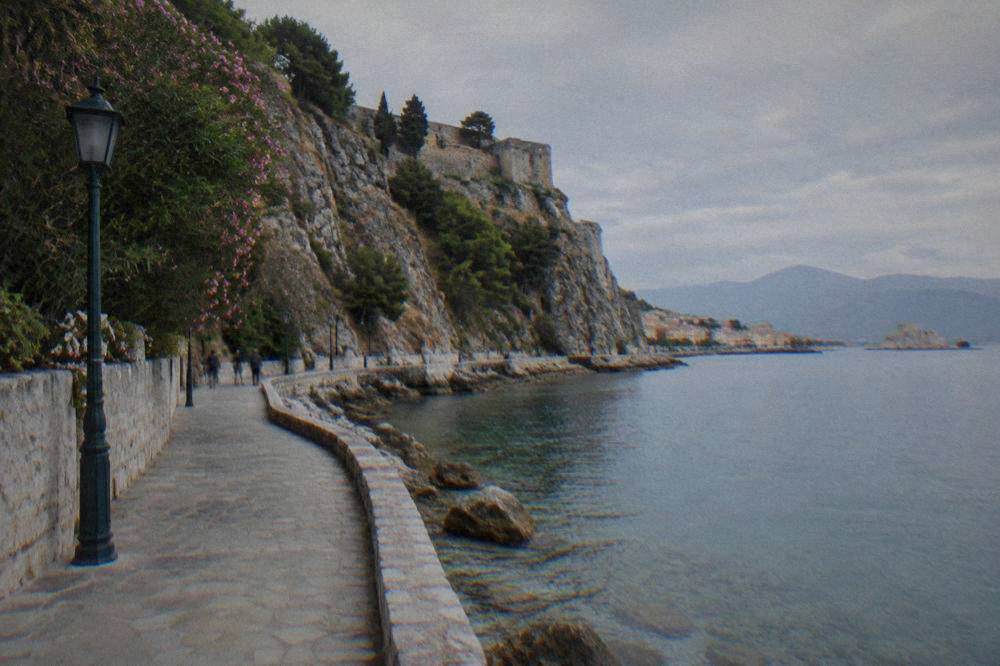
For travellers who like to feel the geography rather than read it, a guided loop beats a map. A cycling, sightseeing and tasting tour traces the flat waterfront and the Arvanitia shore, the two edges where the town meets its gulf, and pairs the ride with the flavours of the Argive plain behind it.
Common Questions About Where Nafplio Is Located
Where Is Nafplio Located In Greece?
Nafplio is on the north shore of the Argolic Gulf, in the Argolid regional unit of the north-east Peloponnese, on the mainland of southern Greece, about 141 km by road from Athens.
Is Nafplio in the Peloponnese?
Yes. It sits in the Argolid, the eastern regional unit of the Peloponnese peninsula, reached by road across the Isthmus at Corinth.
Is Nafplio close to Athens?
Athens is about 141 km away, roughly 127 minutes of driving from Syntagma Square to Syntagma, or a coach journey of about 2 hours 10 minutes on the reported KTEL service.
Is Nafplio on an island?
No. It is a mainland port town. The only islet is Bourtzi, a fortified sea fort in the town's own harbour, reached by boat.
Which islands are near Nafplio?
Hydra, Spetses and Poros lie in the Saronic and Argolic waters to the east. No scheduled public ferry runs from Nafplio or Tolo to them; they are reached by seasonal day cruise or from another port.
What is the nearest airport to Nafplio?
Athens airport, about 171 km away, a computed drive of roughly 2 hours 19 minutes. There is no airport in the Argolid and no passenger train to the town in 2026.